 the highlight will be the Ghan (the red line) in May, when things have cooled down a bit. The Alice Springs-Darwin bit only opened in 2004.
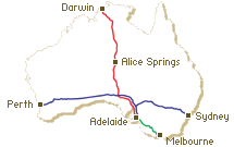
You can get a sense for the terrain by going to maps.google.com and writing in "South Australia," then choosing from the buttons at top right "satellite" or "hybrid." The rail line's not marked on the hybrid map, but you can certainly swoop in on some pretty amazing territory! (Double-click to zoom in.) You can also get very close indeed to the island I'll be on next Wednesday night. Type in "Rottnest Island, Western Australia" and you're there! Now imagine snorkeling in turquoise seas after having crossed the Nullarbor!